May 15 2014//
This following post attempts to reveal the multiple layers of research embedded within a particular artwork – A 2013 Video work entitled Tales From the City (1 minute)
Tales From the City (1 minute) is made up from many different visuals and interconnected strands used to layer, collage and filter memories of the contemporary city both through reality and the imagination.
Underlying themes embedded within the final work and notes about experimental digital processes are recorded here in the form of a digital sketchbook. However, the purpose is to illuminate my practice rather than explain the work as this must function as a self-contained artwork alongside the briefest synopsis.
Whilst work is in progress each visual graphic, photo, audio-clip or map fragment holds personal significance leading me through the process of making. But once the work is complete, only glimpses of these fragments and their origins remain. This post is an attempt to rewind and unravel some of the concepts and processes behind the work.
Drawings and Notes
I currently now work almost exclusively as an on-screen digital artist and no longer keep a ‘proper’ sketchbook in order to work through ideas.
However, occasionally I do make sketches
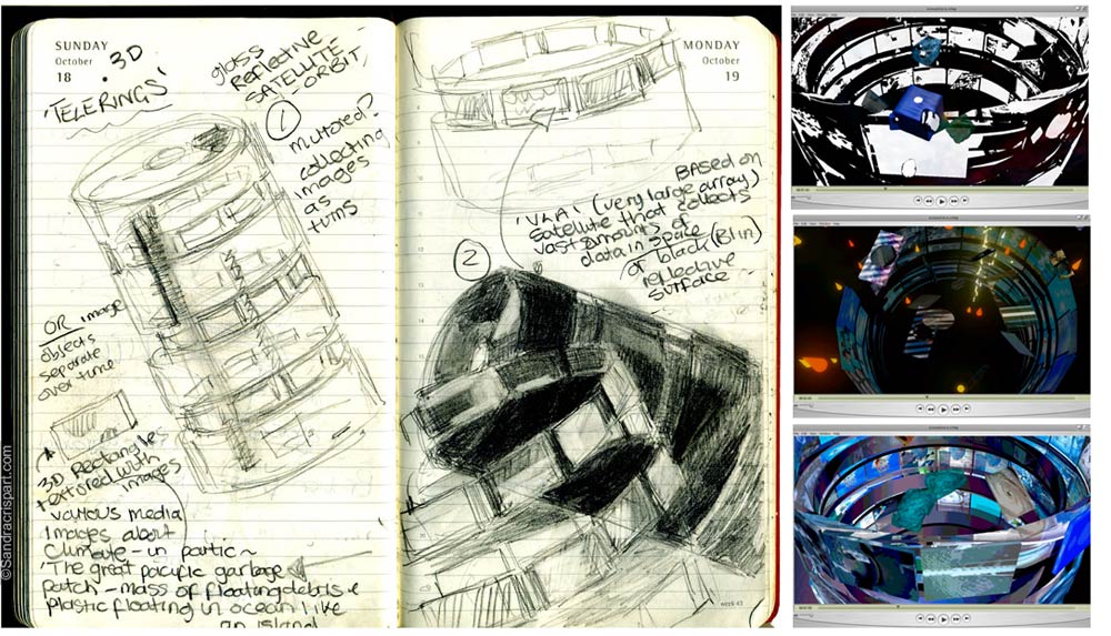
(Left) ‘Telerings’ – A drawing made developing 3d models in a previous video entitled ‘Oceanics’. Pencil drawing in an old diary (Right) Three video stills from ‘Oceanics’ show the same stacked cylindrical structure recreated as 3D models in Maya and textured-mapped with borrowed media visuals. These ‘Telelrings’ are loosely based upon found diagrams showing the inner workings of an orbiting space satellite. I became fascinated by this large -array telescope which collects huge amounts of data and runs in the background hidden from view so that we aren’t aware of it’s complex processes.
However, most of the time I don’t create pencil drawings towards video projects instead preferring the spontaneity and risk involved in drawing and evolving new forms, and ideas directly on the screen.
More often than not, my visual ramblings appear more like these two pages below
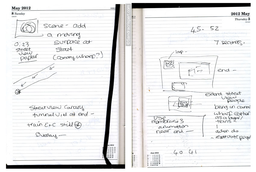
City (1 minute)’
Below, another pencil drawing for Tales From the city (1 minute)
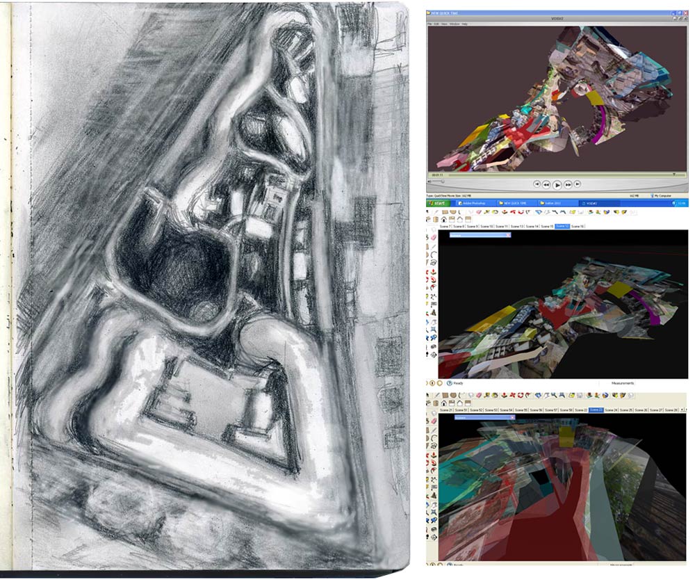
The second city scene in ‘Tales From the City (1 minute)’ incorporates a journey where 3d cameras move through a segment of this model. The original drawing is based upon the rooftop view of an unusually organic local building viewed via Google Earth. The G Earth image was rather distorted and fuzzy and visual information missing – This loss of detail has been translated into the drawing. The imprecise nature of the G Earth image encouraged me to improvise and transform the structure into something entirely new and quite surreal.
I enjoy using technologies such as G Earth and Streetview as they are contemporary processes that reveal the world to us in new ways. We can access the information almost instantly in virtual space
Collage & Texture Mapping
Tales from the City (1 minute) continues my interest in how collage may be reconsidered in terms of new digital media’. With this video and several previous works such as Oceanics I’m using 3D modelling to reinterpet previous layering/ collage approaches used in my large format digital prints such as Memory Surface series, for example. Creating 3D sculptural assemblages that are rotate-able in the space behind the monitor screen.
As in previous videos, models within this video have many different facets and use a technique called ‘texture mapping’ where surfaces may have visuals pinned to them. For texture mapping, I use a vast array of visual material culled from many diverse sources including on-the-fly camera-phone photos rapidly shot whilst walking through the city or borrowed online maps, such as Google Earth and Street View. I also download online visuals that are the results of specific searches connected to work-in-progress ideas and concepts. I often use alpha transparency to evoke a sense of memory in these structures, as if the visuals have attached themselves to surfaces over time.
Although I’d been experimenting with texture mapping for some time in previous works, for this work I reconsidered the different facets and transparent image-surfaces as memory-membranes: Forming a kaleidoscope of continually altering visuals that recall the city in a tumbling time-based stream-of-consciousness.
Opening Sequence – The City
The video begins with the camera rapidly descending into a cluster of multi-coloured models depicting a futuristic and anonymous looking city space. This could be any 21st Century city site but the models are actually based upon Canary Wharf, London, UK.

I used Google Street View map elevations of the area to construct the models. The flattened perspective of the aerial maps acting as a guide to trace out and then elevate the various rectangular structures. The tower block surfaces are textured mapped with visuals of nearby and much older residential Poplar housing estate that exists in the shadow of these wind-swept, glass and steel towering structures. I was thinking about the shift between old and new buildings existing cheek-by-jowl in the city.
Then, as the sequence proceeds, a small rectangular graphic in rapid motion beginning at the bottom left corner of the video frame pops-up and sweeps the viewer into the next contrasting subterranean-like scene – This flickering mini-video thumbnail depicts Street View captured in the moment when the viewer pushes through the virtual streets using a mouse within the browser window.
I am fascinated by Street View’s illusion of reality which is seductive and convincing until a glitch or error in the the seamless panoptical view occurs by way of a blurred-out road, gap between structures or a mis-matched building reminds us that this is really a kind of virtual collage put together by code and algorithms seeming to portray real- World reality.
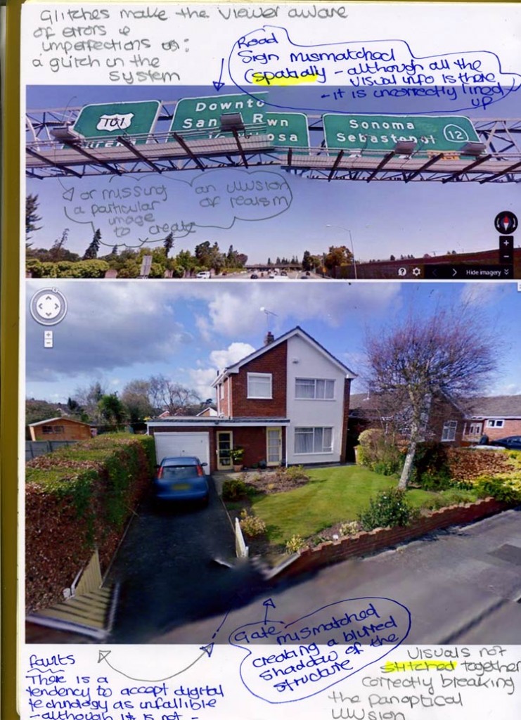
The Heygate Estate Sequence
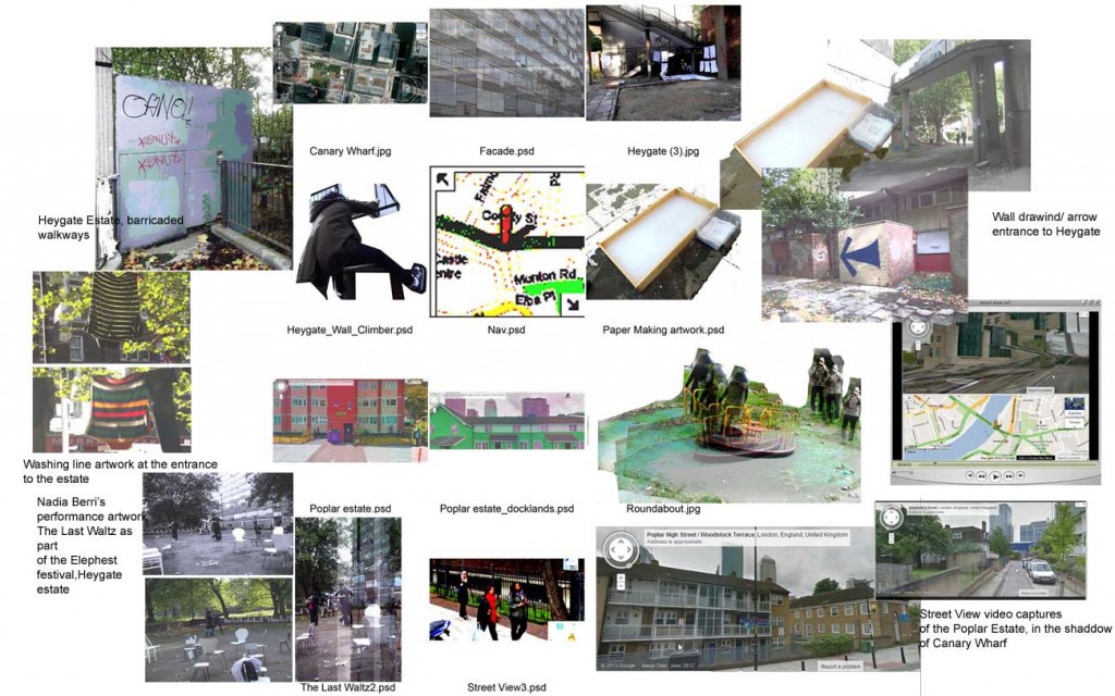
Work on Tales from the City (1 minute) originally began after a visit to the soon-to- be-demolished Heygate housing estate in Elephant and Castle, Wandsworth, London. The estate was home to more than 3,000 people but only a few of the residents now remain. I spent a sunny afternoon in October 2012 meandering around the estate with it’s striking Brutalist buildings, furniture discarded outdoors, boarded up windows and barricaded elevated walkways all pointing towards the Heygate’s imminent demise.
I expected to find a foreboding place but discovered activities taking place such as Parkour in a clearing beneath a dense canopy of old trees and a lush community garden with it’s own irrigation supply, endless wall paintings saturated the walls.
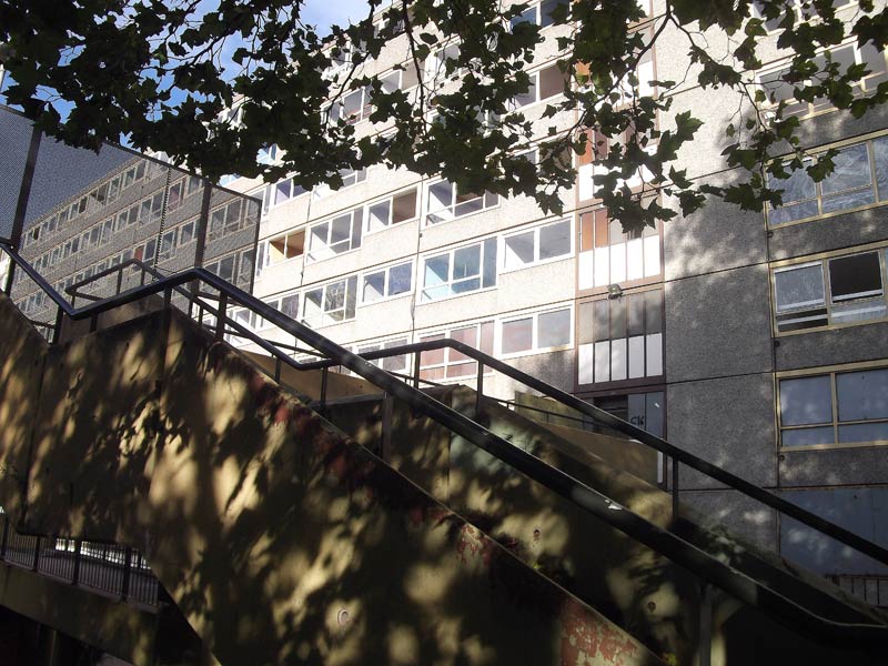
I was fascinated by the cycle of decay accelerated due to the relocation of many of the previous tenants. The photos taken on that day were eventually used in the 2nd subterranean sequence to texture map the labyrinthine 3D model.

1) Articles of clothing attached to a long washing line placed there by one of the artists marking the estate’s entrance 2) Hand-made paper-making underneath the concrete walkways 3) Nadia Berris ‘The Last Waltz’ performance, where the public danced on the crumbling tarmac of the five-aside football pitch
At the time of my visit in October 2012, the Elephest festival was also in full flow and various artist’s site-specific installations added an extra layer of interest to the estate. These artworks were also incorporated into the video
Shortly after my visit I discovered Anna Minton’s book and great page-turner Ground Control ‘Fear and Control In The Twenty First Century’ which is an illuminating and impassioned account of contemporary urban gentrification and loss of personal, and psychological space in 21st Century UK cities – A critique of heavily surveilled, squeaky clean and ordered new city spaces such as Canary Wharf, and Liverpool One.
The book confirmed my own negative perception of over-large oppressive and depersonalised shopping malls that lack the lively/ human cacophony of noise and activity present in the irregular networks of open-air, ground-level city streets. Such ideas eventually permeated the video by way of the contrasting upper and lower-level structures/ spaces and the juxtaposition of organic/ geometric forms and austere/ bustling spaces.
Making the Models| SketchUp experiments| Process| Low-tech
Tales from the City (1 minute) is also a result of experimenting with a free 3D modelling program called SketchUp for the first time. This software is designed so that anyone who is not an expert or CAD trained designer may make detailed models of real-world building or objects.
SketchUp Make (The free version that I use) is not able to render high resolution video frames as Autodesk’s Maya which I used for Oceanics, for example. The animated output option is not really designed for artist’s video, more as a quick and dirty visual tool for architects and planners so the result is thinner colour and less dense contrasting tone. However, I do really enjoy the challenge of co-opting free software such as this and adapting it for my own practice. My approach is to avoid using the software in the more prescriptive ways and pre-set tools in favour of finding and exploring small corners of the software in which to work. Using a rather go-against-the-grain approach in relation to what the software is supposed to do. Using SU to create intuitive, abstract and organic models texture-mapped with collage-based visuals.
Unfamiliarity with new digital process at the start of a project is an advantage as I then avoid the repetitive pitfalls of becoming a technical expert in specific software packages, therefore my practice remains stubbornly low-tech to keep the focus on experimentation and serendipity.
I have always taken the approach of being consistently perfection-adverse in all chosen media including previous printmaking where I exploited the unpredictability of chemical lithography or etching to alter and layer found photographic imagery.
Of course, the drawback to taking such a fly- into-the-unknown software approach is that it can take a long time to find that relevant small corner and many rejected test pieces occur that remain unused! Also, ideas tend to arise as projects progress via ‘thinking through process’ rather than starting at any precise starting point, although I do frequently revisit themes such as the urban environment or today’s media saturation.
SU, originally owned by Google then Trimble, encouraged 3D model production by the public in order to populate Google maps in the form of crowd sourcing – Indeed a pretty clever way for Google to populate their online map apps for free.
Google held a yearly “Model Your Town” competition. These promotions certainly have added to the amount of 3D data in Google Earth, but the world is a big place and it would likely take centuries of such projects before the data was collected in one country, let alone the world.
As a result of the past connection to Google, the current version of SU still has a very useful tool via a pop-up window that can connect with and download images directly from Street View without leaving the actual program window. A feature that I happily used to directly grab Earth visuals and attach them to the surfaces of models.
Creating a Model
SU is really quite user-friendly even for beginners to make basic geometric models onscreen, facets can be grabbed and extruded using a ‘push/pull’ tool (See diagram below)
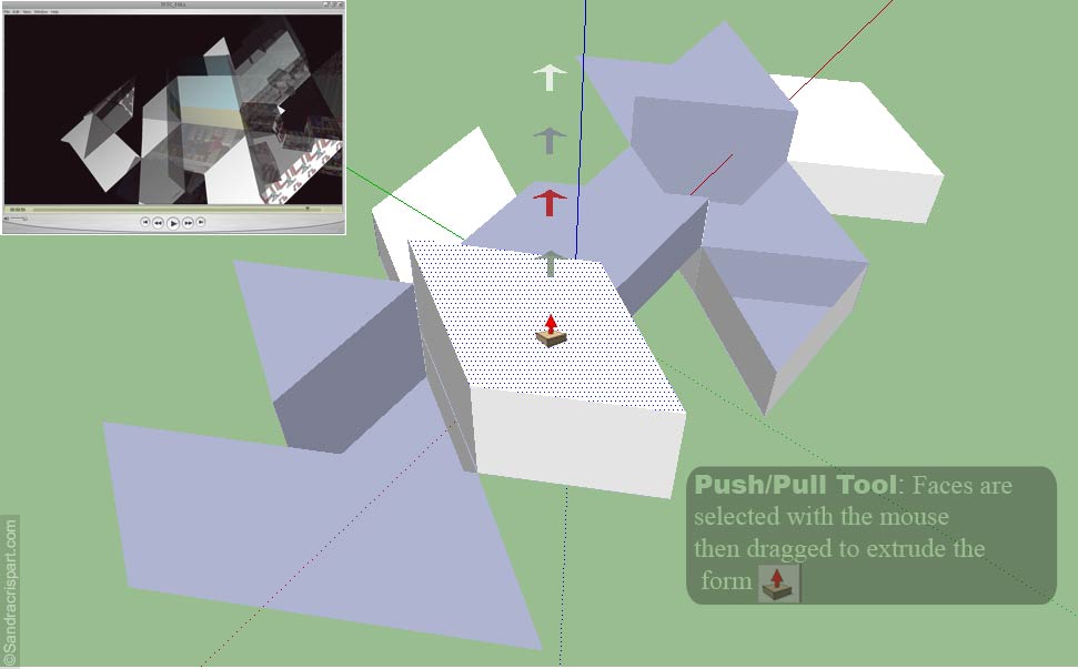
Eventually I found a way to sketch out more fluid line drawings and forms, still using a mouse to draw with but this time using a freehand draw tool in the software’s menu. This allowed for 3D models that are much more intuitive, unpredictable and organic such as the subterranean sequence in the video.
When I first started wroking with SU and experiments progressed with model making, and texture-mapping I discovered that a camera could be ‘taken for a walk’ around these virtual models to form an animated sequence viewable in SU. Then, I eventually figuring out a way to export these sequences to Quick Time or TARGA image-sequence files and reassemble them in video editing software, such as After Effects to produce the final video.
I always start new work in the same position of anxiety thinking that I should know exactly where I am going. However, aside from vague starting points and intentions on the peripheries of mind, I never do – Work has to evolve gradually through process resulting in a convergence of many different elements over time.
By shifting visuals from physical reality ‘out there’ (in the form of the Heygate photos for example) into digital space and transforming online Street View maps, and drawings of Google Earth into digital models – I am interested in exploring how digital tools may be used to filter reality through memory and the imagination, and how these new online spaces are continually forming new realities.
————————————————————————————————————————————————————-
Links
*Texture mapping is a method for adding detail, surface texture (a bitmap or raster image), or color to a computer-generated graphic or 3D model.’
**Buckminster Fuller’s Dymaxion map projection on Wikipedia
More of my camera phone photos taken at the Heygate can be found on a previous post HERE
View Tales From the City (1 minute) HEREE
Southwark Notes Whose Regeneration? blog by Southwark residents about the Heygate estate development and imminent demolition.
Ground Control ‘ Fear and Unhappiness In The Twenty First Century‘ by Anna Minton on Good reads